Define what level changes the data must reliably detect
Groundwater time series can look precise while carrying a systematic error. A moved reference point creates a step; pressure/venting problems create drift; pumping produces drawdown/recovery; clock errors shift correlations with rainfall or operation. Validate the measurement chain before interpreting hydrology.
Start by writing the operational question in one sentence: What independent evidence would distinguish a real aquifer change from a datum, sensor, pumping or timing problem? Then define who will act, how quickly they must act, and what independent evidence will confirm that the action worked. A reading that cannot change a decision may still be useful for research, but it should not be confused with an operational alert. For water-level sensor validation, the most common design error is to instrument the measurable variable before agreeing on the service decision it is meant to improve.
Use validation rules that respect pumping and datum context
Protect raw data
Protect raw data. Corrections are part of interpretation, not a reason to overwrite observations. Store raw value, correction and corrected value separately. This makes the decision inspectable: another operator can see what condition triggered the choice, what evidence should be recorded, and what would cause the choice to be revisited.
Check step changes against work logs
Check step changes against work logs. Sensor service often coincides with artificial jumps. Compare configuration, datum and installation records at the step time. This makes the decision inspectable: another operator can see what condition triggered the choice, what evidence should be recorded, and what would cause the choice to be revisited.
Compare with a reference
Compare with a reference. Automatic sensors can drift invisibly. Take independent manual/reference readings on a defined schedule. This makes the decision inspectable: another operator can see what condition triggered the choice, what evidence should be recorded, and what would cause the choice to be revisited.
Use context before attribution
Use context before attribution. Pumping and recharge can explain short-term movement. Join pump state, time and relevant hydrologic context before calling a trend regional. This makes the decision inspectable: another operator can see what condition triggered the choice, what evidence should be recorded, and what would cause the choice to be revisited.
Record paired manual and automated measurements
A field design is only reproducible when the variables behind it are visible. The table below is a minimum record for water-level sensor validation. Do not replace unknowns with optimistic defaults. Mark them unknown, collect the missing observation during the pilot, and record the date and method used to resolve them.
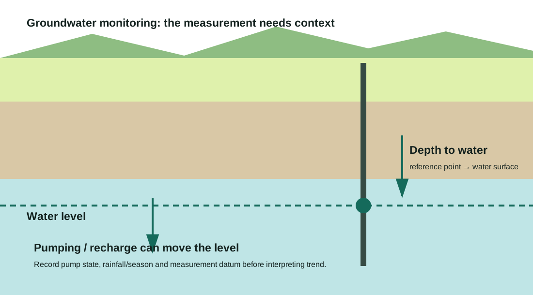
Keep the validation context with each check: measuring point, manual depth-to-water, automated value, transducer depth, barometric value if used, pump state and timestamp. A discrepancy is only interpretable when both readings refer to the same datum and operating condition.
| Variable | Record | Why it matters |
|---|---|---|
| Raw reading | sensor units | Preserves original evidence. |
| Datum/reference | offset/elevation | Makes readings comparable. |
| Manual check | reference value/time | Detects drift/offset. |
| Pump state | on/off/recent runtime | Explains drawdown/recovery. |
| Pressure/temperature | as applicable | Supports compensation diagnosis. |
| Correction version | method/date | Makes QA auditable. |
Investigate datum, compensation and pumping before calling a trend
Remote monitoring collapses several failure domains into one screen. A flat line, a missing packet and a real infrastructure fault can look similar if the telemetry does not expose device health. For water-level sensor validation, use the sequence below before assigning a repair crew. The purpose is not to delay urgent response; it is to prevent a communications or sensor fault from being mislabeled as an asset failure.
For an unexpected level shift, check datum changes, cable movement, barometric compensation, pumping, clock error and recent maintenance before labelling it groundwater change. Compare with nearby wells or precipitation only after the local measurement chain has been ruled out.
| Observed pattern | Likely checks | Next action |
|---|---|---|
| Instant step after service | datum/config/offset change | Reconstruct from service record and reference check. |
| Gradual divergence from manual | drift/vent/pressure issue | Inspect sensor and apply documented correction only if justified. |
| Cyclic drawdown/recovery | pumping effect | Interpret with pump schedule/runtime. |
| All wells shift same timestamp | backend/unit/time conversion | Audit ingest/config before hydrology. |
Commission the transducer against the physical measuring point
At commissioning, take paired manual and automated readings, verify the measuring-point reference and repeat after the sensor has settled. If pumping occurs, capture at least one static or clearly labelled pumping condition so future drawdown is not confused with an installation offset.
For water-level sensor validation, complete the following steps in order. If a step fails, correct it before treating later successful steps as proof of readiness. A cloud dashboard receiving one packet is not enough if the sensor reference, timestamp, power behavior or alert route is still unverified.
- Plot raw values and flag exact times of sensor/well work.
- Check units, datum, sensor offset and timestamp/timezone configuration.
- Compare the nearest independent reference reading with the logger value.
- Overlay pump state or known abstraction and relevant environmental context.
- Classify the issue and document any correction formula/version.
- Retain raw series and re-run trend calculations from corrected, quality-flagged data.
Set discrepancy and timestamp acceptance limits
Acceptance should define allowable manual-to-sensor discrepancy, timestamp alignment and the response to missing or implausible values. Include a repeat check after a known interval so the process can detect early drift rather than only installation mistakes.
Choose validation limits from sensor performance and management use. A threshold for detecting seasonal change should not be copied into a system making near-real-time pumping decisions without considering expected drawdown, noise and response delay. Record the reason for the chosen tolerance.
- Raw preservation — Original readings remain exportable.
- Datum — Reference point/offset is documented.
- Agreement — Reference checks meet the programme tolerance or are flagged.
- Context — Pumping/service events are joinable to the series.
- Corrections — Method and date are explicit and reversible.
- Trend — Trend analysis excludes/handles flagged periods consistently.
Worked example
Scenario. A logger suddenly reports water 0.45 m deeper immediately after enclosure work, while a manual check finds no comparable change.
Calculation or rule. The coincidence and independent check make a datum/offset change more plausible than an aquifer step. Reconstruct the old/new reference offset from installation records before applying any correction.
Interpretation. Do not smooth the step away; correct only with documented evidence and retain the raw record plus correction metadata. The example is intentionally transparent so the inputs can be replaced with local values rather than copied as a universal recommendation.
What field guidance changes water-level validation
USGS monitoring guidance makes reference practices, observation purpose and measurement frequency central to groundwater data quality. EPA sensor guidance also emphasizes marking calibration events and bad data so downstream algorithms do not treat them as real anomalies.
Quality flags and service metadata are first-class data. They are needed to explain changes that the numerical time series cannot explain by itself. Published deployment evidence is useful here as a design constraint, not as a promise that another programme will achieve the same result. Geography, spare-parts logistics, institutional incentives, staffing and connectivity all change outcomes.
Annotate every intervention that can create an artificial step
Do not freeze the configuration after launch. Review water-level sensor validation after the first meaningful operating period, after any firmware/network change, and whenever false alarms, unexplained data gaps or missed failures appear. The review should compare the original decision requirement with actual response times and data quality, then change only one major rule at a time when possible so the effect can be observed.
Annotate transducer replacement, cable-depth changes, measuring-point work, barometric-source changes and offset corrections. These events are common causes of artificial steps; without annotations, automated trend analysis can treat maintenance as a real aquifer response.
- Schedule independent reference checks.
- Audit datum after any wellhead/enclosure work.
- Review drift plots before seasonal trend reporting.
- Keep correction code/version with exported datasets.
Sources and limits
Use these references to verify the underlying guidance. Local regulations, operator coverage and manufacturer instructions can change the correct implementation.
- USGS: Ground-Water-Level Measurements — Why Frequency MattersUSGS says measurement frequency should be chosen from the monitoring objective and be sufficient to separate short-term and long-term hydrologic effects.
- USGS Climate Response NetworkUSGS describes groundwater observations ranging from periodic manual readings to continuous 15–60 minute sensing, with site-selection controls for climate response.
- US EPA water-quality sensor evaluation guideEPA emphasizes calibration, data acquisition design and marking calibration events, warnings and bad data so analytics do not treat them as actionable anomalies.
- NASA GRACE/GRACE-FO drought monitoringNASA describes GRACE-derived groundwater and soil-moisture indicators for broad drought context; these are regional indicators, not substitutes for a local well measurement.